


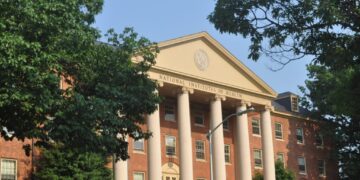


A partially covered section of the Yakima-Tieton Irrigation District’s main canal. Located at the base of a hillside that sustained significant damage from the Rimrock Retreat Fire, the area has been deemed a high risk for landslides and debris flow. Photo by Emily Fitzgerald.
A 115-year-old canal in the Yakima-Tieton Irrigation District that was severely damaged during the Rimrock Retreat Fire last year is now at imminent risk of failure.
Fixing the 12-mile waterway will cost an estimated $229 million and involve work spread over more than a decade. But if the canal suddenly goes out of service, officials say it could cause up to $3 billion in losses over three years for 35,000 acres of farms and 28,000 acres of orchards in the Yakima Valley that are part of the irrigation district.
Surrounding communities also rely on the canal to deliver water to fire hydrants and other municipal fire suppression systems.
The irrigation district has tapped $5 million in county, state and federal funds to help extend the life of the canal, and the two-year capital budget the Legislature approved this year included an additional $8.5 million for repairs and improvements.
While those funds will keep water flowing for now, the deteriorating state of the canal and the high risk of a catastrophic failure mean the canal needs to be replaced as soon as possible.
Construction would take place outside the growing season over the course of 15 years, with $15.3 million paid per year.
The Yakima-Tieton Irrigation District has committed $80 million through a 30-year bond and is looking for other sources, including state and federal funding, to pay for the rest of the project.
“We’re trying to figure out how to put all this together, because this is a massive project that our district cannot shoulder alone,” said Travis Okelberry, district manager of the Yakima-Tieton Irrigation District, during a tour of the Rimrock Retreat Fire area this week.
“The canal delivers a river’s supply of water to an otherwise arid valley … If this canal system fails, it will absolutely devastate the Yakima Valley,” Okelberry said.
The Yakima-Tieton Irrigation District has been working on a plan to replace the aging canal since 2013 and approved a gravity-fed boxed culvert design as its preferred alternative in 2024.
As the irrigation district was working on a project plan, however, the Rimrock Retreat Fire broke out.
The fire started at a Rimrock Retreat cabin in July of last year and burned roughly 46,601 acres between Rimrock Lake and Tieton in the Yakima Valley over a month.
The full length of the canal was in the burn area.
“There were logs and trees and boulders crashing into, on top of, and rolling down through our canal system. It tore apart the inside of the canal. There’s massive spalling and heat damage to the outside of the canal,” Okelberry said.
The weakened integrity of the concrete has led to more leaks, with canal patrolmen documenting over 2,000 active leaks as of last week, Okelberry said.
“We’ve done our best to seal them up during the off season,” he said.
The fire also significantly increased the risk of landslides, debris flows and runoff on the hillside above the canal.
As mild as this spring’s rainfall was, Department of Natural Resources Recovery Program Manager Colin Haffey said that, without the normal vegetation to slow the flow of water through the watershed, they saw dangerous amounts of water flow over the top of the canal this year.
Debris flows after Mount St. Helens erupted in 1980 buried a mile-long section of the canal. A thunderstorm that occurred shortly after that debris flow further clogged the canal with ash and mud from the eruption, which caused a large section of the canal to flood and peel away from the hillside.
To prevent a repeat of those problems and help mitigate damage throughout the burn area, the Department of Natural Resources’ wildfire-associated landslide emergency response team completed a geological survey of the Rimrock Retreat Fire area in September 2024.
The survey determined the areas most prone to landslides, flash floods and debris flows after the fire, as well as areas that would be most beneficial to monitor with trail cameras or flood sensors for early hazard detection.

Nancy Calhoun, Washington Geological Survey post-fire debris flow program manager, points to an high risk area for debris flow near the Yakima-Tieton Irrigation District’s main canal on a map developed by the wildfire-associated landslide emergency response team after the Rimrock Retreat Fire. Photo by Emily Fitzgerald.
The survey team focused primarily on assessing the dangers to people and infrastructure, including the canal and Highway 12.
Based on the findings of the survey, the Yakima-Tieton Irrigation District spent $2 million this year to cover 12,000 feet of the canal in landslide-prone areas.
That funding was part of a total of $5 million for immediate repairs and improvements to mitigate future damage.
The irrigation district, Yakima County and the U.S. Bureau of Reclamation, as well as the state Department of Natural Resources, Department of Commerce and Department of Ecology all contributed funds.
Repairing and fortifying the canal has been a primary focus of Rimrock Retreat Fire recovery efforts due to its value to the surrounding community.
“There’s no difference between the built environment of this canal and the natural environment of this watershed. Both are critical to the community,” Haffey said.
This post was originally authored and published by Emily Fitzgerald from Washington State Standard via RSS Feed. Join today to get your news feed on Nationwide Report®.